If you visit this page you may notice that apart from programming I’m strongly interested in cartography. I decided to look at the issue of transport development in the area where I live (Tricity) and prepare some maps regarding this topic. My main goal is to present a theoretical (and certainly impossible to build) possible routes of the metro system. I want to cover this topic in two articles. In the first one (which you are reading) I will briefly outline the geographic conditions of the region (demography, population density, terrain). In the next article, I would like to present how the region’s current transportation system looks like and how potential subway lines can be designed to supplement the existing network. Of course, this is not a scientific work. I made maps, collected data and wanted to summarize my conclusions.
Current situation
In country I live in (Poland) there is only one metro system located in the capital - Warsaw. With it’s population of 2 millions there are only two lines built so far. There are plans to build next lines, but there won’t be any new lines completed in the next few years. Other cities have no metro system construction plans so far and there won’t be in the nearest future. Large cities in Poland are focusing on expanding the existing infrastructure - new tram lines, bus fleet, creating hubs. The reason is simple - cost. Public transport is not a profitable industry and the cost of building a metro line in a densely populated area is enormous. Additionally, topographic conditions mean that the costs of this project would increase by astronomical levels. I will present this on maps.
Metro systems in cities of comparable size
There is a question - should small cities extend their transportation network by building a metro line? We know that huge metropolitan areas like New York, Tokio, Moscow, Paris or London have their extensive metro systems which are under constant development. But much smaller urban areas also have them, and some have been built recently. Below are the examples of urban areas with comparable population to Tricity. You will learn about the details related to the population of Tricity in the next paragraph.
| City/Urban Area | Population | Lines | Opened |
|---|---|---|---|
| Bilbao | 1 000 000 | 3 | 1995 |
| Glasgow | 1 861 000 | 1 | 1896 |
| Genoa | 580 000 | 1 | 1990 |
| Naples | 909 000 | 3 | 1993 |
| Rennes | 360 000 | 2 | 2002 |
| Samara | 1 163 000 | 1 | 1987 |
I want to point out that Tricity is not too small to have it’s own metro system.
Population
Tricity consists of 3 cities:
| Name | Population | Area [km²]* |
|---|---|---|
| Gdańsk | 486 345 | 683 |
| Gdynia | 242 874 | 391.5 |
| Sopot | 32 276 | 28 |
| Total | 761 495 | 1102.51 |
Source: Wikipedia, data as of 2023
*According to the new law introduced as of January 1, 2023, the area of administrative units also includes marine areas.
The Tricity metropolitan area also include other cities and communities:
| Name | Population |
|---|---|
| Wejherowo | 46 271 |
| Rumia | 52 931 |
| Reda | 28 588 |
| Pruszcz Gdański | 32 093 |
Source: Wikipedia, data as of 2023
Depending on which units we include in the agglomeration, the population of the area can be estimated at 1-1.5 million. The most populated neighborhoods are near the center of the cities, and along the main railroad line. The municipalities that surround the Tricity are increasing their population every year. Gdansk, Gdynia and Sopot are cultural and industrial centers for the entire region. For many people in the neighboring municipalities, the Tricity is also a place to work.
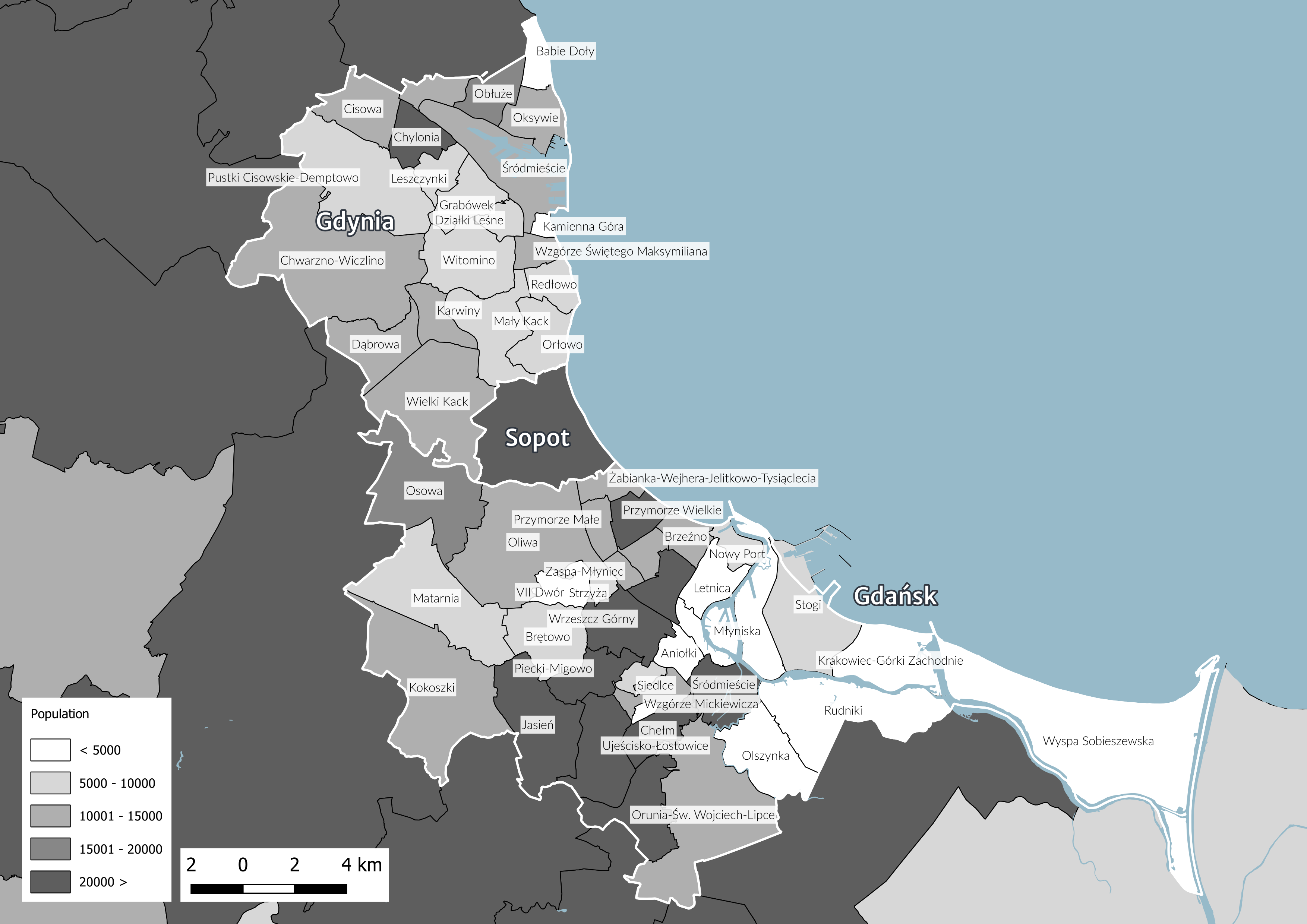 Population in the municipalities. For Gdańsk, Gdynia and Sopot, data is presented in the districts. Click to see full image.
The highest densities are in neighborhoods created in the 1960s and 1970s. The majority of structures in these areas consist primarily of tall apartment buildings, ranging from 4 to 12 floors in height.
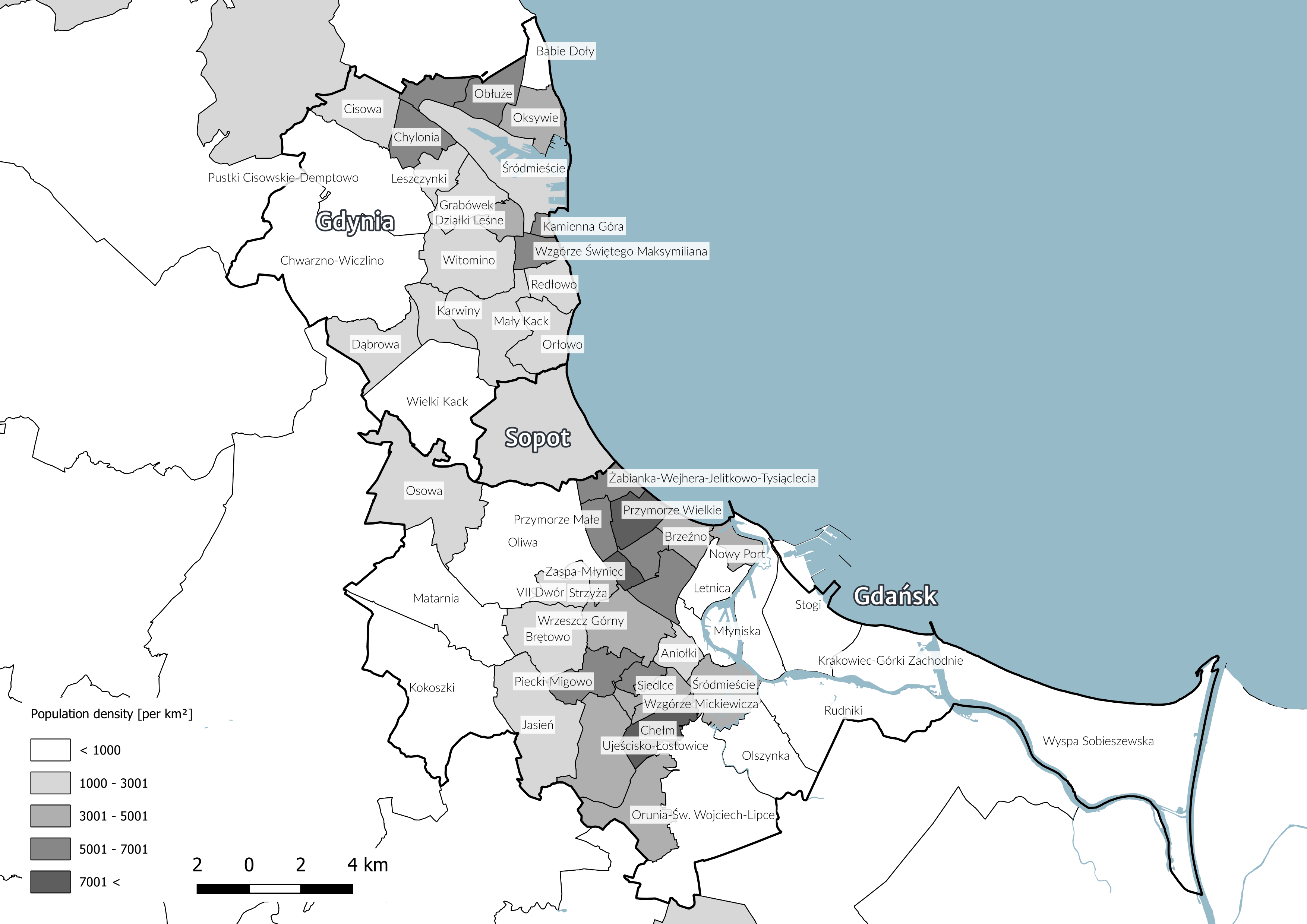 Population density in the municipalities. For Gdańsk, Gdynia and Sopot, data is presented in the districts. Click to see full image.
Topography
In my opinion the type of local topography is the main factor that prevents the build of the metro system or make it at least very complicated. Tricity is located on the coastline of the Baltic Sea. Eastern part of Gdańsk is located on the delta area of the river Vistula. This part is flat, deforested and covered by wetlands. The proximity to the sea also means that ground water is at a fairly high level in the coastal area. However a sizable part of the Tricity is located in the highlands. A few kilometers from the shore, the terrain begins to rise to heights as high as 180-200 m. The change in terrain elevation occurs over a short distance. It can also be noted that only a narrow strip (4-5 km) along the sea is located in the area below about 80-100 m above sea level. These two main conditions:
- significant differences in elevation
- wet terrain
Make it very expensive and difficult to build a subway line in the area.
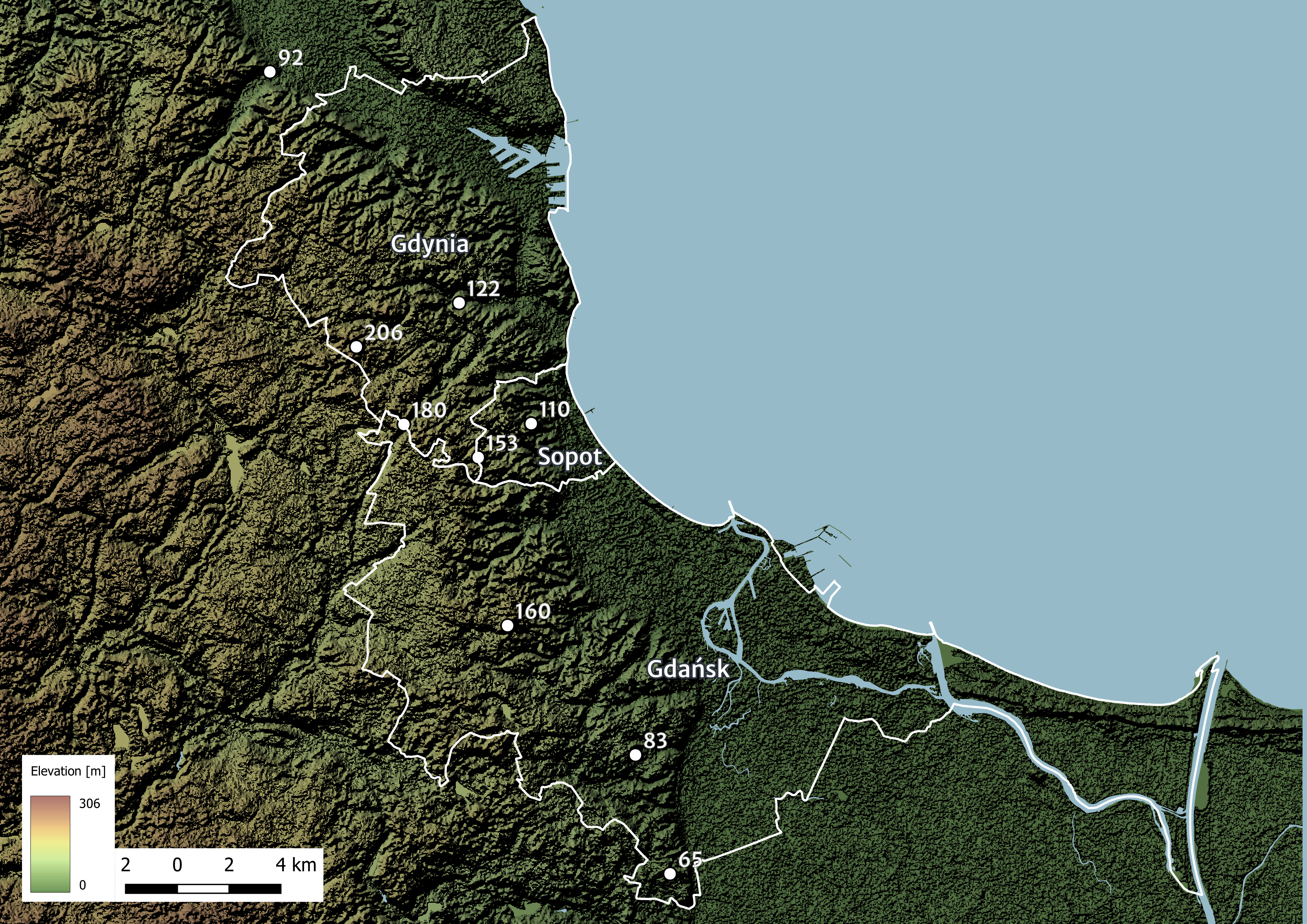 Elevation map with marked elevation points of Tricity region. Click to see full image.
*All maps are made by me.